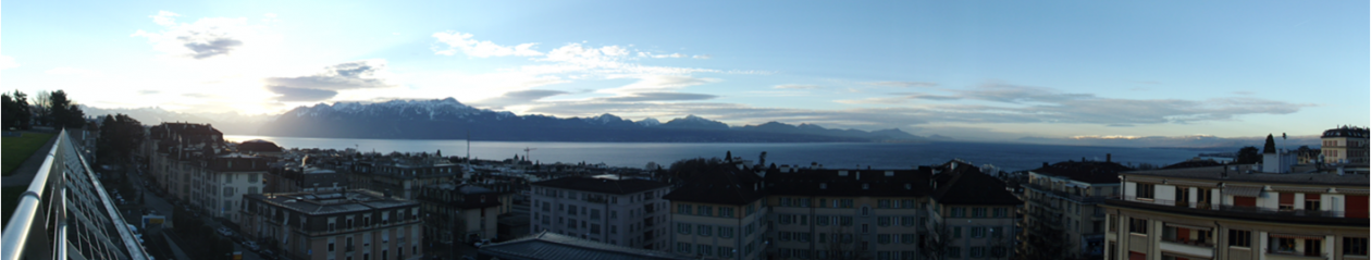
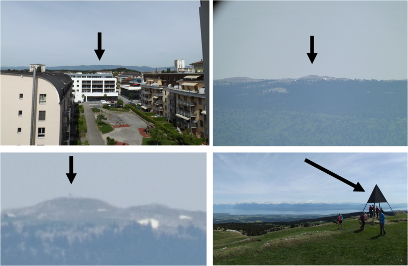
Iconic to Switzerland are the Alps with their sheer snow-capped peaks rising throughout the southeast of the country. Lesser known are the Jura mountains with rounded tree covered tops running the length of the French border. The second highest peak in the range is Mont Tendre at 1,679 m (5,509 ft); just 13.5 miles from our apartment it dominates the view out of our dining room window. From our apartment, with our camera’s zoom maxed out, I can just barely make out the pyramid structure placed to mark the summit.
We haven’t been doing much the last few weekends, so this last weekend we thought climbing the mountain would be a fun excursion close to home. We checked the weather and picked Sunday May 10th because it was rightly forecasted to have clear skies. Our path to the top required two train rides, a bus ride, then a 7.3 km (4.5 mile) hike up the western side. If we had a car it would have been a much shorter trip in time and distance. On the steeper eastern side there is a road that goes up to a restaurant from which the hike is only 850m (0.53 miles).
We began our journey around 10:30 a.m. and an elevation of around 415m (1362ft). The first train traveled a wide serpentine route to just outside of Vallorbe, Switzerland. The second train traveled through steep terrain up to the shores of Lac de Joux. Every turn and bump our rail car creaked and whined as if to complain about the effort. It was so exceptionally noisy that Melissa made a video to document it. The last leg of our public transport was a bus that took us along the scenic southeastern shore of Lac de Joux to the village of Les Bioux.
At around 11:45 a.m. and an elevation around 1021m (3350ft) we were ready to begin our hike. The start of the trail was hard to find, so we ended up using google maps and walking up a mountain road for a while until we found the yellow hiking trail signs.
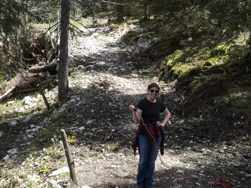
The trail starts out steep, then levels off through cow pastures and forest (with occasional steep parts), and ends with a long steep stretch up to the summit. The steep parts took extra effort to hike, because they were all littered with large rocks trying to make you fall or twist your ankle.
We packed a lunch and ate it along the way, and also drank most of our water by the time we reached the summit. We had packed 2 liters of water, but in hindsight more would have been better. We didn’t find any water faucets along the trail.
For us hiking through the pastures was a little strange, and different from hiking in the U.S. Every so often we’d come up to a fence and have to climb over it or unfasten an electric wire to walk through, then reconnect it. We were a little uncertain at first that the signs were correct, and afraid that a farmer might come out and ask us what we were doing, but after seeing more signs and people along the trail we soon realized hiking through pastures is the Swiss way.
The trail is very scenic for about the first mile. You start out by the lake and as you climb higher and higher, more and more of the lake and valley come into view. Then the trail enters woods and pastures, and there aren’t many more long distance views until the very end.
It’s a long hike. The lack of dramatic scenery along with trail signs that estimate the time to the summit made us question a few times if it was worth it to go all the way. But we did!
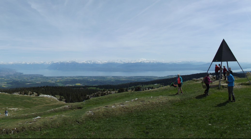
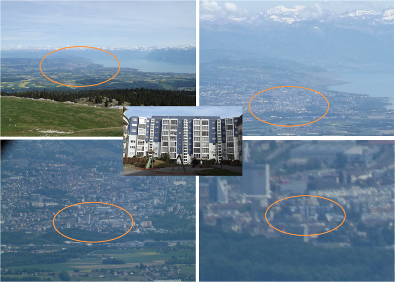
Around 2:45 p.m. we made it to the top and were rewarded with the most amazing view in Switzerland yet. We could see the entire length of Lake Geneva, Lake Neuchatel to the northeast, and the Alps all along the horizon, with Mont Blanc on the French/Italian border 59.5 miles away as the farthest sight. I could also max out the zoom on the camera and see all the way down to our apartment.
The hike down was easier than the hike up. We got back to the bus station around 5 p.m. Then had to wait an hour for the bus to show up. Two days later we are both still a little bit sore, but happy for the experience. Check out the album below with views along the trail and from the top.


